Welcome to PLOSON Brand website!
 +86 137 6027 1017
  ploson@163.com , Sales Contact : Eugene (WeChat:CN20290101)
Product Center
——


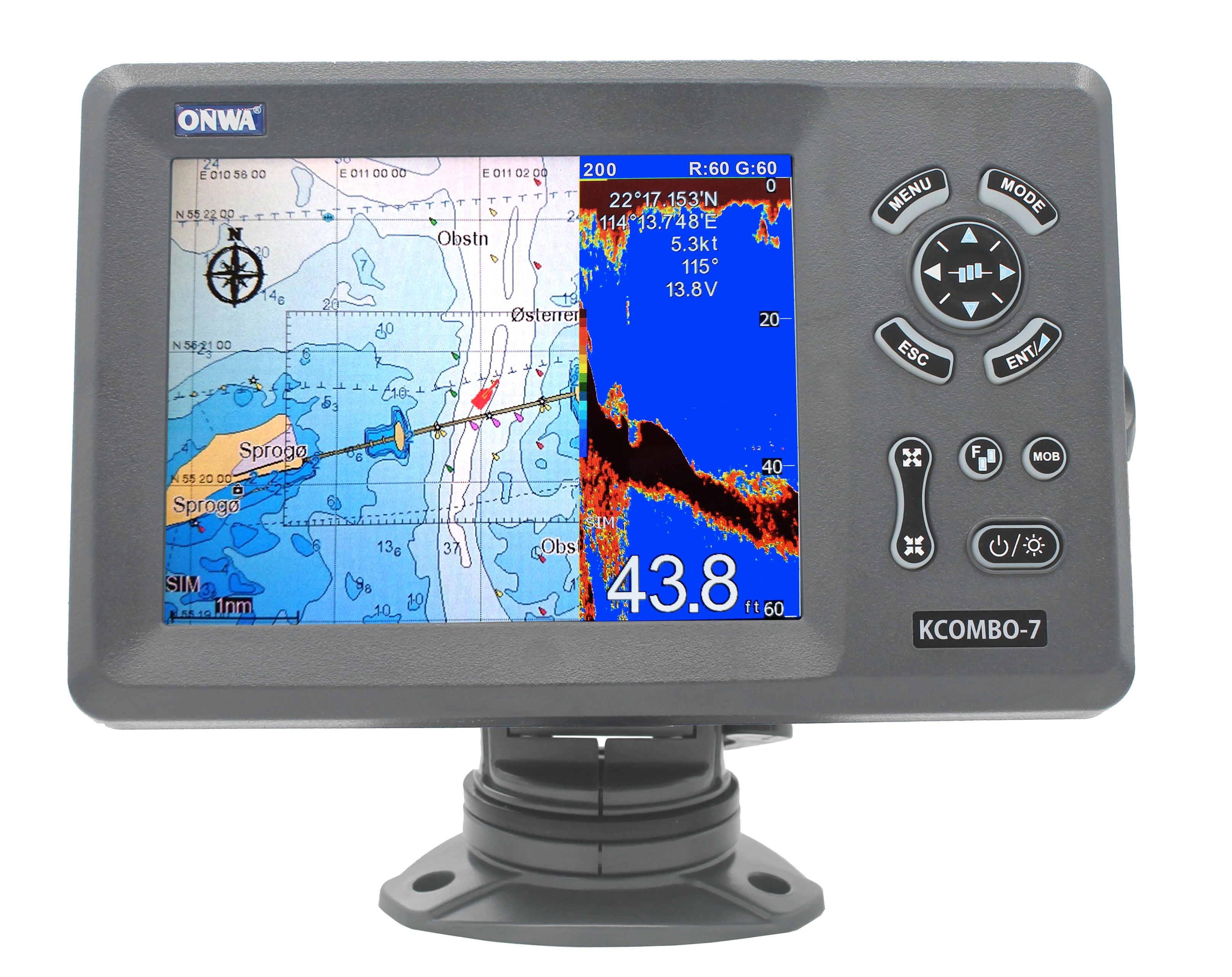
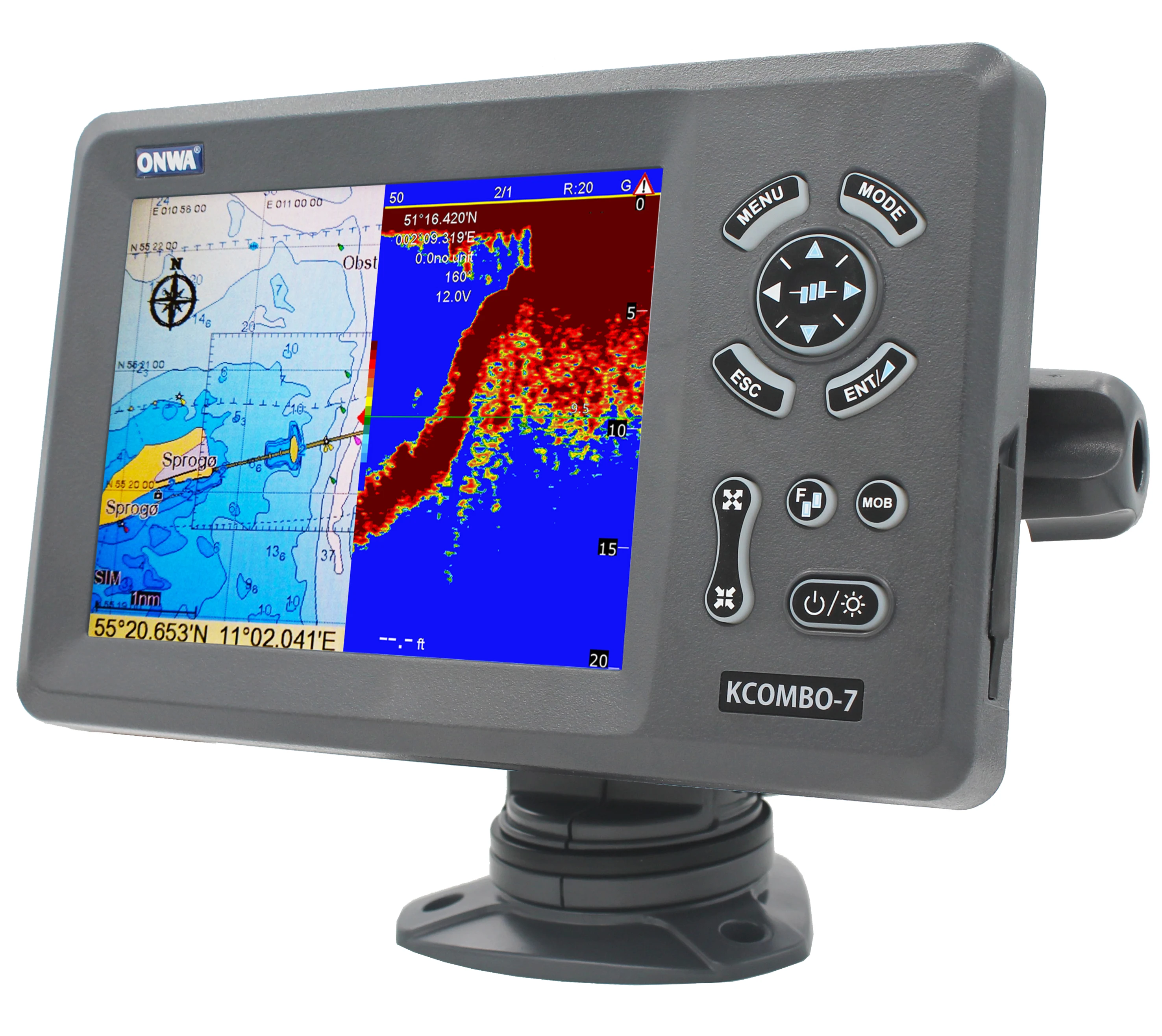
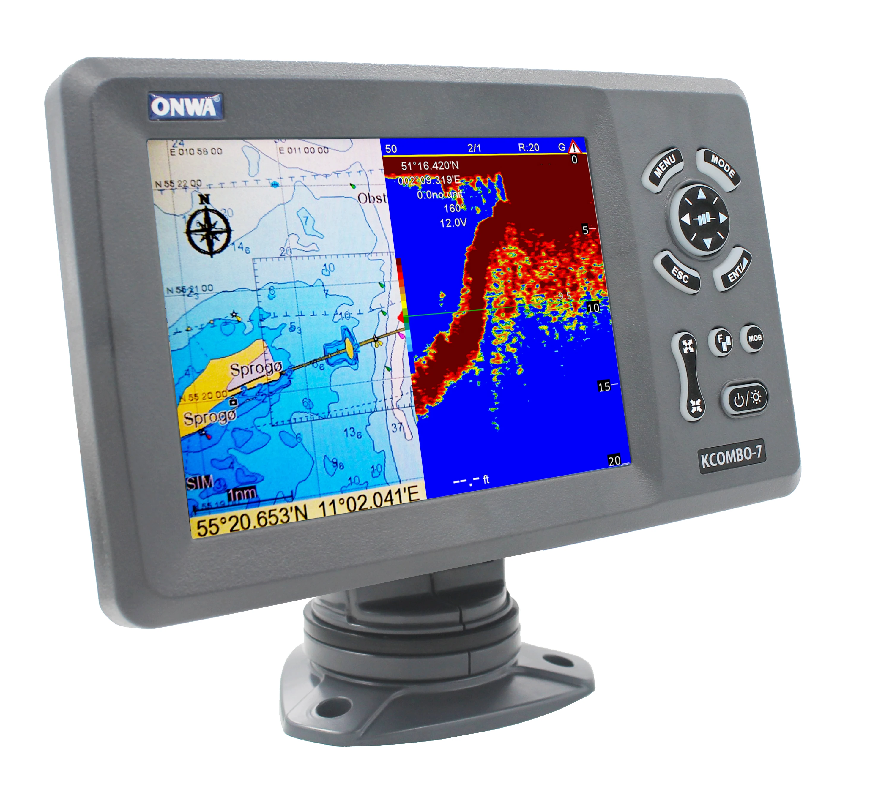
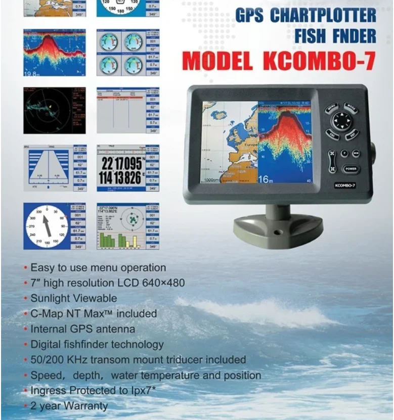
ONWA K-Combo7A 7-inch marine gps chartplotter combo with Fish Finder K-Combo7
KCombo-7A
7-inch GPS Chart Plotter with Fish Finder and built-in Class B+ AIS Transponder
Specifications
Plotter Characteristics
Waypoints/icons
12,000 user waypoints with name, symbol,
3 system waypoints: MOB,Start,cursor
10 proximity waypoints
Routes
30 routes waypoint up to 170 points each,
plus MOB and Track Navigation or Goto Track modes
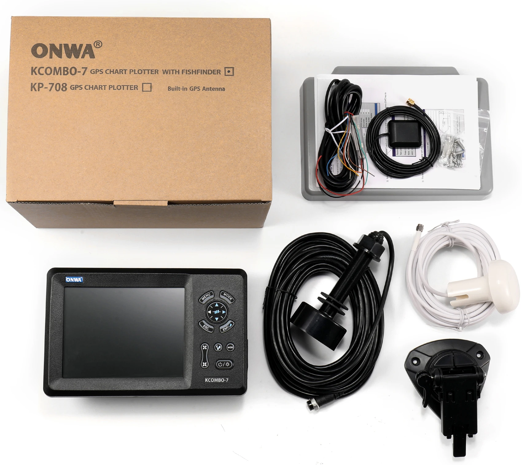
 kcomno 7A , GPS +FISHFINDER +AIS
including:with chart (with Map (Note: Chart of which sea is required))
and TD-25 ( TD-25 with Cable 10M Sonar Small Waterproof Transducer Depth Transducer ),
and GPS Antenna (HA-017 with cable 10M)
TD-25Transducer Depth Transducer:


FEATURES:
7″ Color LCD GPS C-Map MAX compatible plotter with Fishfinder Combowith Internal GPSAntenna and built-in Class B AIS Transponder
- 7 inches High resolution LCD,640×480 pixels
- Choice of External or Internal GPS Antenna (Specify when ordering)
- Built-in Class B AIS Transponder
- Easy to use menu operation
- sunlight viewable
- C-Map NT Max Compatible
- Digital Fishfinder Technology
- 50/200 KHz transom mount transducer(Optional Accessory)
- Speed, Depth, water temperature and position
- Ingress Protected to IP67
* VHF Antenna Needed for the AIS transmission (not included, optional accessory(KA-156/KA-162-X))
MODELS:(SPECIFY WHEN ORDERING)
Product Name :7" Color Marine AIS/GPS Plotter combo Fishfinder
Product Category :AIS Devices
Plotter Characteristics
Waypoints/icons
12,000 user waypoints with name, symbol,
3 system waypoints: MOB,Start,cursor
10 proximity waypoints
3 system waypoints: MOB,Start,cursor
10 proximity waypoints
Routes
30 routes waypoint up to 170 points each,
plus MOB and Track Navigation or Goto Track modes
plus MOB and Track Navigation or Goto Track modes
Tracks
8,000 points automatic track log;
10 saved tracks (up to 8000 track points each)
lets you retrace your path in both directions
10 saved tracks (up to 8000 track points each)
lets you retrace your path in both directions
Alarms
XTE, Anchor drag, arrival, speed, voltage, proximity waypoint,
Timer and AIS (CPA and TCPA) alarm
Timer and AIS (CPA and TCPA) alarm
Drawing
1000 Drawing Marks; 2000 Drawing Lines (40 points each);
1000 Drawing Place Name; 8 colors for Drawing
1000 Drawing Place Name; 8 colors for Drawing
Pallete
Normal
Daylight exposed to sunlight
Night in dark environment
NOAA paperchart colors
Daylight exposed to sunlight
Night in dark environment
NOAA paperchart colors
Tides
Built-in Worldwide Tide Data
Position Format
Lat/Lon
Basemap
Worldwide
External Map
Compatible with K-Chart 2.0, K-Chart 3.0, C-Map Max and Navionics+
User Data Storage
Internal backup of user settings or external SD-card
Plot Interval
5secs to 60 mins or 0.01 to 10nm
Plotting Scales
0.001 to 700nm
Perspective view
On/off (available for C-Map only)
Celestial
Sunrise/Sunset Moonrise/Moonset
GPS Receiver Characteristics
Receiver
50 parallel channel GNSS receiver continuously tracks and
uses up to 50 satellites to compute and update your position
uses up to 50 satellites to compute and update your position
Acquisition time
Cold start: 29 seconds
Hot start: 1 second
Hot start: 1 second
Update rate
1 second or 0.1 second selectable
Accuracy
Position:3 meters(95%) without S/A
Velocity: 0.1 meter/sec without S/A
Velocity: 0.1 meter/sec without S/A
SBAS
Supported
QZSS
Supported
Satellite System
Choice of 4 GNSS: GPS, Beidou, GLONASS and Galileo
Dynamics
Altitude: 18,000 m
Velocity: 515 m/s
Velocity: 515 m/s
Datum
WGS 84 & user defined
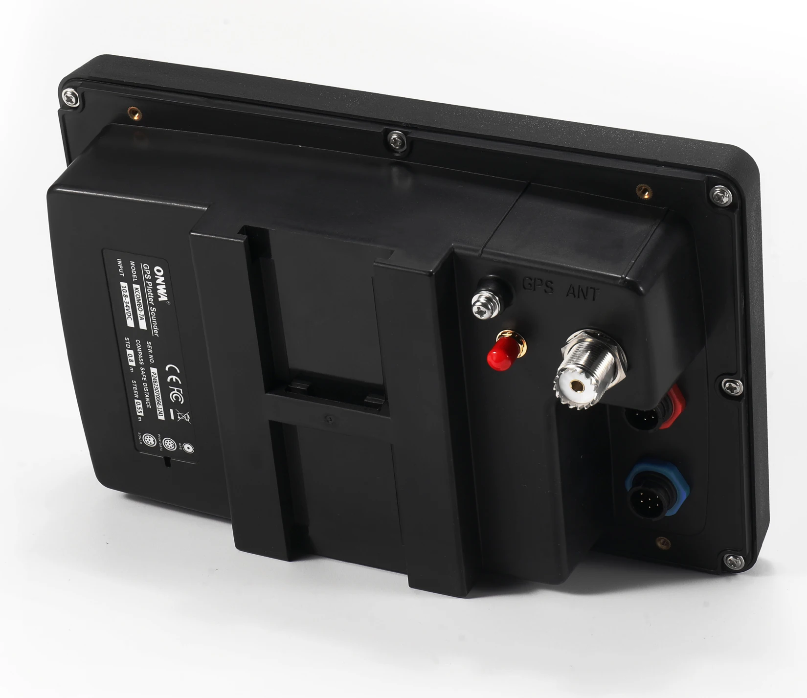
Antenna
GPS Patch Antenna
GPS Interface
GSP Data
RS232 input/output, NMEA 0183 V3.01 and V4.11
GPS Input Baudrate
Auto Scan (4800, 9600, 19200 and 38400)
GPS Output Baudrate
Selectable among 4800, 9600, 19200 and 38400
AIS Interface
AIS Data
RS232 output VDO, VDM, GGA, GSA, GSV and VTG
AIS Input Baudrate
38,400 from GPS Input Port
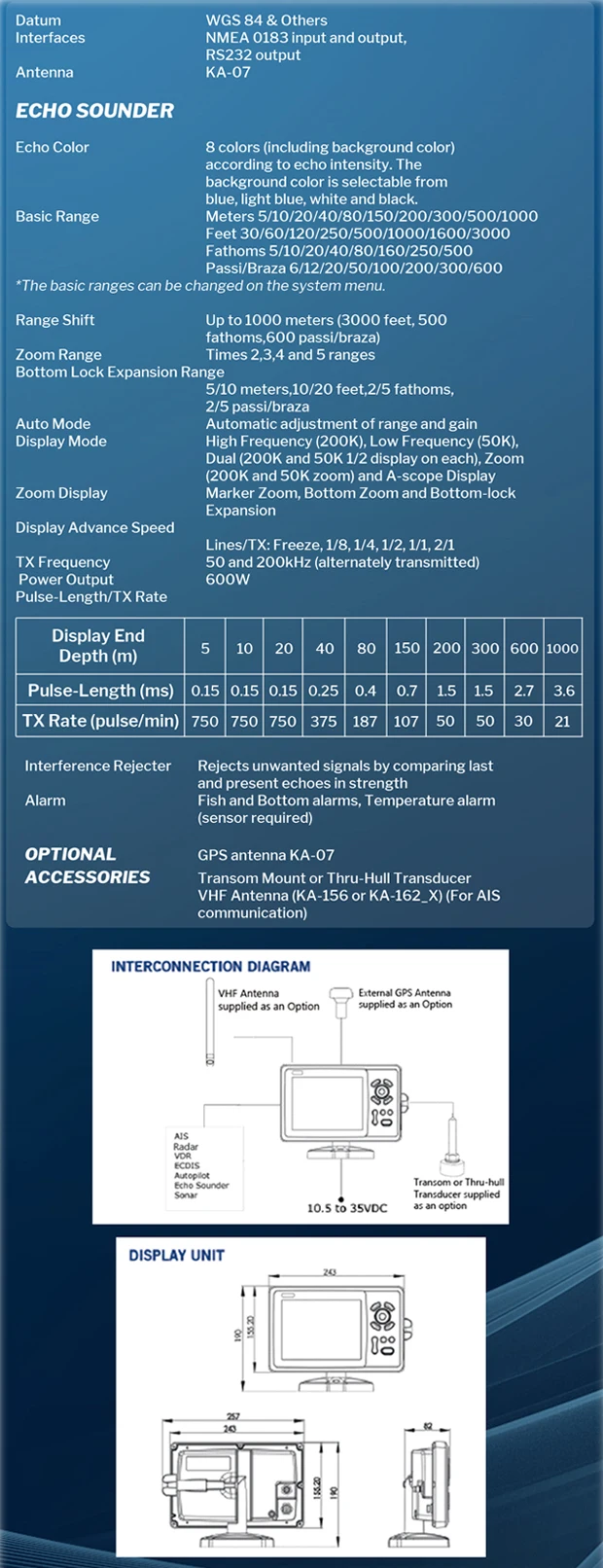
Echo Sounder Characteristics
Echo Color
16 colors (including background color) according to echo intensity. The background color is selectable from blue, light blue, white and black
Basic Range
Meters 5/10/20/40/80/150/200/300/600/1000
Feet 15/30/60/120/200/400/600/1000/2000/3000
Fathoms 3/5/10/20/40/80/150/300/600
*The basic ranges can be changed on the system menu.
Feet 15/30/60/120/200/400/600/1000/2000/3000
Fathoms 3/5/10/20/40/80/150/300/600
*The basic ranges can be changed on the system menu.
Range Shift
Up to 1000 meters (3000 feet,600 fathoms)
Zoom Range
Times 2,3,4 and 6 ranges
Bottom Lock Expansion Range
5/10 meters,10/20 feet,2/5 fathoms
Auto Mode
Automatic adjustment of range and gain
Display Mode
High Frequency (200K),Low Frequency (50K), Dual (200K and 50K 1/2 display on each),
Zoom (200K and 50K zoom) and A-scope Display
Zoom (200K and 50K zoom) and A-scope Display
Zoom Display
Marker Zoom, Bottom Zoom and Bottom-lock Expansion
Display Advance Speed
Lines/TX:Freeze, 1/8, 1/4, 1/2, 1/1, 2/1, 4/1, 6/1,8/1 and 10/1
TX Frequency
50 and 200kHz (alternately transmitted)
Power Output
600W
Pulse-length/TX rate
Display End Depth (m) | 5 | 10 | 20 | 40 | 80 | 150 | 200 | 300 | 600 | 1000 |
Pulse-Length 200K(µs) | 120 | 220 | 320 | 520 | 920 | 1020 | 1020 | 1020 | 1020 | 1020 |
Pulse-Length 50K(µs) | 170 | 270 | 370 | 570 | 970 | 1070 | 1070 | 1070 | 1070 | 1070 |
TX Rate(pulse/min) | 2000 | 1333 | 706 | 353 | 171 | 98 | 75 | 53 | 38 | 27 |
TX period(millisecond) | 30 | 45 | 85 | 170 | 350 | 610 | 800 | 1120 | 1580 | 2200 |
Interference Rejecter
Rejects unwanted signals by comparing last and present echoes in strength.
Alarm
Fish and Bottom alarms,
Temperature alarm (sensor required)
Temperature alarm (sensor required)
NMEA Sentence Supported
INPUT
(Auto scan Baudrate)
GGA, GLL, GSA, GSV, RMC, HDG, HDM, HDT
VTG, ZDA, MTW, VWR, VWT, MWD, VPW, VHW
TLL, TTM, VDO, VDM, GNS, MTA
RMA, DBT, DPT, MWV, BWC, XTE, ZDL, WPL, AAM,
APB, BOD, RMB, DSC, MDA, RPM, XDR
GGA, GLL, GSA, GSV, RMC, HDG, HDM, HDT
VTG, ZDA, MTW, VWR, VWT, MWD, VPW, VHW
TLL, TTM, VDO, VDM, GNS, MTA
RMA, DBT, DPT, MWV, BWC, XTE, ZDL, WPL, AAM,
APB, BOD, RMB, DSC, MDA, RPM, XDR
OUTPUT
Baudrate: Selectable 4800, 9600, 19200, 38400
GGA, GLL, RMC, GSA, GSV, AAM, APA
APB, BOD, BWC, BWR, DBT, DPT, HDT
MTW, RMB, TLL, VTG, WPL, XTE, ZDA
ZTG, ZDL, MWD, VPW, VWR, VWT
GGA, GLL, RMC, GSA, GSV, AAM, APA
APB, BOD, BWC, BWR, DBT, DPT, HDT
MTW, RMB, TLL, VTG, WPL, XTE, ZDA
ZTG, ZDL, MWD, VPW, VWR, VWT
OUTPUT for Autopilot
APA, APB, BOD, XTE
Power Supply
10.5 to 30VDC, current drain 1.5A at 12V
PHYSICAL
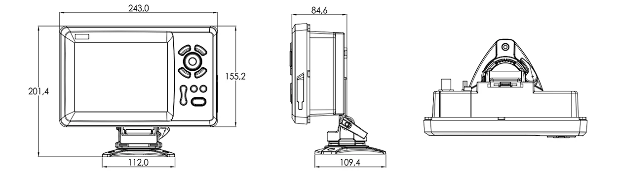
Size
155.2mm(H)X243mm(W)X84.6mm(D)
Weight
0.6 kg
Display
7-inch Color TFT dayview LCD, 800×600 pixels
Waterproofing
Display unit: IP66
Antenna unit: IP66
Antenna unit: IP66
Temperature range
Display unit: -15℃ to +55℃
Antenna unit: -25℃ to +70℃
Antenna unit: -25℃ to +70℃
Equipment List
Display unit
Quick manual
GPS Patch Antenna with 4m cable (SMA connector)
Mounting Brackets
Standard accessories pack
Quick manual
GPS Patch Antenna with 4m cable (SMA connector)
Mounting Brackets
Standard accessories pack
Previous : ONWA marine Update KM-8 and KM-12 Series
Next : ONWA K-Combo7 7-inch marine gps chartplotter combo with Fish Finder


 Copy product links
 Long by picture save/share
INQUIRY


Add Successfully
To Get PLOSON Marine Hardware Information, Discount Message And How-To Knowledge Articles From PLOSON Marine.


PLOSON PL-SN3 N-Female 3-way RF Splitter Power Splitter 2Way 3Way 4Way GPS/Galieo/Gnss signals Power Divider

PLOSON PL-SN2 N-Female 2-way RF Splitter Power Splitter 2Way 3Way 4Way GPS/Galieo/Gnss signals Power Divider


PLOSON PA-07 1 pcs Marine GPS Antenna with 10 meter cable BNC Male connector RF Cable 10m RG-59 TNC Interface Waterproofing IPX6


ONWA KP-25A 5-inch GALILEO GPS Chart Plotter with GPS Antenna and Built-in Class B+ AIS Transponder Combo Marine GPS Navigator

ONWA KP-27F 7-inch Marine GPS Chart Plotter Marine Built-in Fish Finder depth sounder sonar fish finder With TRANSDUCERS
+fish transducer")
ONWA KM-8C 8-inch GPS Chart Plotter with GPS Fish Finder/depth sounder/Echo sounder (supports Expanded Features)+fish transducer
 Chart Plotter Marine GPS Navigator")
KP-39 7inch ONWA marine GPS Chart plotter (with K-Chart Map Chart sea) Chart Plotter Marine GPS Navigator

PLOSON HAB-130 Marine Boat Fishing boat Positioning apparatus AIS Fishing Net with Antenna IPX7 GPS Anti-lost Tracker Locator

XA-201 Automatic Identification System Marine marine AIS class B transponder transducer Built-in WIFI by Phone APP

HA-102 Marine AIS receiver and transmitter system 5 watts CLASS B AIS Transponder Dual Channel Function CSTDMA Function


AR-10 Dual Channel AIS Class A Class B AIS Receiver with Antenna SMA Connector for Boat Marine with USB output

HAR-100 AIS Receiver Dual Channel AIS Class A and Class B Receiver With RS232/ RS422 GPS receiver Class AIS Receiver

NPC-100 AIS Pilot Plug USB data cable 2 Meter IMO Standard AIS Pilot Plug interfaces USB 2.0 cable
INQUIRY
Add Successfully
Contact Us
Tel:+86 137 6027 1017
Sales Contact : Eugene
WeChat:CN20290101
E-mail:ploson@163.com
Address:TaiWanHuaYuan No.27 DongYuan Rd, Shenzhen, Guangdong 518030, China
PLOSON
Copyright @ Ploson All Rights Reserved 粤ICP备10062013号
点击右上角
分享给朋友吧
